Property Record
402 N Wall St, Calhoun, GA 30701


Save to a Folder
{{folder.Name}}
{{folder.ListingIds.length}} Properties
{{folder.ListingIds.length}} Property
Create a New Folder
Property Detail
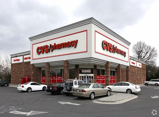
402 N Wall St
C24-105
CVS PHARMACY
Drugstorepharmacycvswalgreens
Gordon
C-2
Georgia
B and X Area of moderate flood hazard, usually the area between the limits of the 100-year and 500-year floods.
1.48 AC
2025
Georgia Northwest
2025
Other Market Areas
970301
Calhoun, GA
10,940 SF
NEARBY LISTINGS FOR SALE OR LEASE
DEMOGRAPHICS near 402 N Wall St
1 mile
3 mile
5 mile
2025 Total Population
4,707
25,555
34,468
2030 Population
4,919
26,886
36,275
Pop Growth 2025-2030
+ 4.50%
+ 5.21%
+ 5.24%
Average Age
37
38
39
2025 Total Households
1,808
9,497
12,706
HH Growth 2025-2030
+ 4.48%
+ 5.06%
+ 5.12%
Median Household Inc
$49,323
$56,641
$60,268
Avg Household Size
2.50
2.60
2.60
2025 Avg HH Vehicles
2.00
2.00
2.00
Median Home Value
$269,270
$239,896
$239,649
Median Year Built
1975
1986
1987
Nearby Places
Map Layers
Map Styles
 Street
 Aerial
Layers
 Traffic
 Biking
Places
Listings with unknown addresses are not visible on the map
- Restaurants
- Banks
- Shops
- Fitness
- Groceries
Nearby Properties
Address
Land Use
TOTAL SIZE
Lot Size
Zoning
Address
Land Use
TOTAL SIZE
Lot Size
Zoning
5,040 SF
13.39 AC
C-2
Address
Land Use
TOTAL SIZE
Lot Size
Zoning
215,296 SF
19.94 AC
R-2
Address
Land Use
TOTAL SIZE
Lot Size
Zoning
209,387 SF
42.22 AC
R-1
Address
Land Use
TOTAL SIZE
Lot Size
Zoning
26,922 SF
19.71 AC
R-2
Address
Land Use
TOTAL SIZE
Lot Size
Zoning
18,640 SF
75.10 AC
C-2
Address
Land Use
TOTAL SIZE
Lot Size
Zoning
3,636 SF
34.97 AC
R-2
Address
Land Use
TOTAL SIZE
Lot Size
Zoning
197,500 SF
14.55 AC
IND-G
Address
Land Use
TOTAL SIZE
Lot Size
Zoning
192,578 SF
25.47 AC
C-N
Address
Land Use
TOTAL SIZE
Lot Size
Zoning
85,560 SF
3 AC
C-2
Address
Land Use
TOTAL SIZE
Lot Size
Zoning
4,318 SF
19.26 AC
IND-G
Address
Land Use
TOTAL SIZE
Lot Size
Zoning
3,360 SF
25.27 AC
RC-1
Address
Land Use
TOTAL SIZE
Lot Size
Zoning
554,897 SF
42.41 AC
IND-G
Address
Land Use
TOTAL SIZE
Lot Size
Zoning
88,000 SF
8.87 AC
IND-G
Address
Land Use
TOTAL SIZE
Lot Size
Zoning
128,740 SF
42.95 AC
IND-G
Address
Land Use
TOTAL SIZE
Lot Size
Zoning
28,481 SF
24.41 AC
R-1B
Address
Land Use
TOTAL SIZE
Lot Size
Zoning
69,000 SF
22.11 AC
I-1
Address
Land Use
TOTAL SIZE
Lot Size
Zoning
6,956 SF
7 AC
R-2
Address
Land Use
TOTAL SIZE
Lot Size
Zoning
96,533 SF
3.53 AC
R-2
Address
Land Use
TOTAL SIZE
Lot Size
Zoning
806,290 SF
74.96 AC
IND-G
Address
Land Use
TOTAL SIZE
Lot Size
Zoning
73,792 SF
5.38 AC
C-2
Address
Land Use
TOTAL SIZE
Lot Size
Zoning
63,612 SF
8.67 AC
I1
Address
Land Use
TOTAL SIZE
Lot Size
Zoning
17,685 SF
25.67 AC
C-2
Address
Land Use
TOTAL SIZE
Lot Size
Zoning
51.30 AC
IND-G
Address
Land Use
TOTAL SIZE
Lot Size
Zoning
54,257 SF
2.42 AC
C-2
Address
Land Use
TOTAL SIZE
Lot Size
Zoning
16,274 SF
12.25 AC
CU
Address
Land Use
TOTAL SIZE
Lot Size
Zoning
32,360 SF
7.40 AC
IND-G
Address
Land Use
TOTAL SIZE
Lot Size
Zoning
20,072 SF
66.16 AC
A-1
Address
Land Use
TOTAL SIZE
Lot Size
Zoning
11,192 SF
14.97 AC
IND-G
Address
Land Use
TOTAL SIZE
Lot Size
Zoning
49,805 SF
6.97 AC
C-2
Address
Land Use
TOTAL SIZE
Lot Size
Zoning
498,811 SF
59.07 AC
IND-G
The World's #1 Commercial Real Estate Marketplace
Connect with us
© 2026 CoStar Group
The information above has been obtained from sources believed reliable. While we do not doubt its accuracy we have not verified it and make no guarantee, warranty or representation about it. It is your responsibility to independently confirm its accuracy and completeness. Any projections, opinions, assumptions, or estimates used are for example only and do not represent the current or future performance of the property. The value of this transaction to you depends on tax and other factors which should be evaluated by your tax, financial, and legal advisors. You and your advisors should conduct a careful, independent investigation of the property to determine to your satisfaction the suitability of the property for your needs.